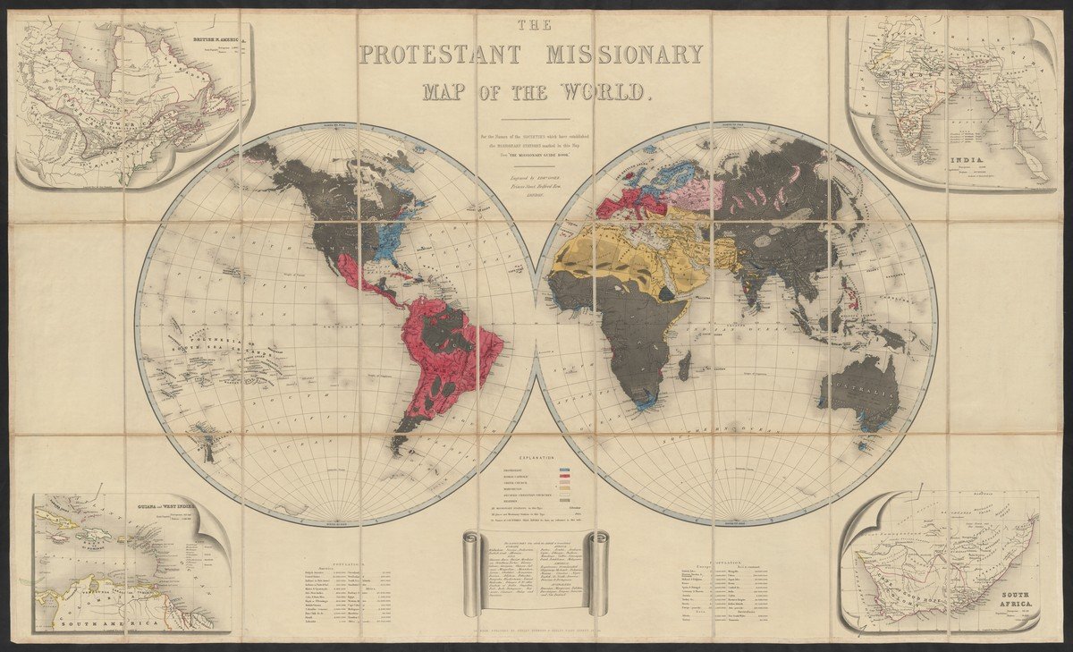
'The Protestant missionary map of the world', 1846
This map from 1846 is a showpiece of the Special Collections Department of Utrecht University. Only a few copies can be found worldwide. The world map is depicted in two hemispheres, with insets of India, South Africa, British America (Canada) and the Caribbean in the four corners. The legend contains lists of population numbers by country and of languages into which the Bible has been translated. Missions are marked by names of cities but are not clearly visible. On the inset maps, ‘natives’ and ‘Europeans’ are broken down by population.
Colors mark the major religions: blue refers to Protestant, red to Catholic, pink to Orthodox (Greek), yellow to Islamic, dark blue to ‘Decayed Christian churches’, the rest are grey to mark the areas of ‘Heathens’. In this period Hinduism and Buddhism were still often seen as ‘heathen’ and not as a separate world religion. The map is colored by hand, and there are also versions in circulation where the heathen areas are black. In general, these color patterns are typical of missionary cartography, although some variation does occur. In Western culture - and more specifically in cartography - blue usually has a positive connotation (as with the UN blue helmets), while red often indicates danger. Islamic areas were often colored yellow or green. In early missionary cartography, pagan areas were often colored grey or black, in later maps white, showing a shift from ‘dark areas’ (unlit by the gospel) to ‘open areas’ (not yet reached by the gospel).
The map appeared in 1846 and was accompanied by a manual with the telling title: The missionary guide-book; or, a key to the Protestant missionary map of the world: shewing the geography, natural history, climate, population, and government of the several countries to which the missionary efforts have been directed; with the moral, social, and religious condition of their inhabitants. Also, the rise and progress of missionary operations in each country. Illustrated by forty-five wood-cuts, representing the costume of each people. The engraver, Edward Gover, was active between about 1840 and 1854, producing many maps on a variety of subjects, both religious and secular.


