
Fortification map of Bergen op Zoom and surroundings
Bergen op Zoom in French hands
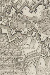
Almost 300 years ago the western part of Europe was anything but a politically stable region. In the 18th century several countries continued battling for power during the many wars of succession. The battles were especially concentrated round the fortified towns, often resulting in long-term sieges. That is why those cities and their surrounding areas were mapped in great detail. This map from 1740 depicting the surroundings of Bergen op Zoom is a nice example.

Impression of the landscape
The beautifully engraved map gives a penetrating picture of the former defense lines around Bergen op Zoom. Not only the many defense works around the city have been painstakingly mapped but also the landscape. Heights such as dunes are often drawn three dimensionally (‘in elevation’), as well as the woods and the wooded banks. With the help of this map one gets a very good impression of the condition the landscape in those days and of the strategic positions of the various fortifications. The map can be viewed georeferenced, making a comparison with the current landscape possible.

Up to date
During the 18th-century wars of succession the audience wanted to be kept up-to-date about the latest war negotiations. Book sellers used this opportunity to print and publish pamphlets. Also newspapers reported about the war, but they mainly covered the local communities and regions. The publishers covered a larger area by the publication of news maps: printed maps with a clarifying image of a siege or battle, with or without an explanatory text. In addition the printed fortification maps showed the actual strength of the European fortifications. The map of Bergen op Zoom and its surroundings falls into this latter category.

For a French audience
The map is in the French language, which was not unusual for those days. But it is actually a genuine French product, designed by an unknown French engineer and published in Paris by Bernard-Antoine Jaillot. That is why we may safely assume that the map was meant for a French audience. A clue for this can be found in the immediate cause for the publication of the map. The cartouche at the bottom right makes it clear, in translation, that the map is made ‘after the attack of the king’s army on 16 September 1747’. This points at the French siege that lasted from 12 July up to 16 September 1747 during the Austrian War of Succession (1740-1748). As the map clearly shows, inundations were located along the line from Bergen op Zoom to Steenbergen (in the north, not on the map). With the help of the map the inhabitants of France could picture the local situation where the acts of war had taken place.
The conquest of Bergen op Zoom
The French troops led by count Von Löwenthal bombarded Bergen op Zoom from 20 July onwards, severely damaging the city. In the south-east also ditches were dug, making a further approach to the city possible. Here, at the bastions of Coehoorn and Pucelle, the French concentrated their attack. Medio August 1747 they conquered the lunettes of Zeeland and Utrecht which were located in front of both bastions. Early September the French started to harass the bastions themselves and the Dedem ravelin in between, resulting in breaches in the defense and on 16 September the French managed to march into the city. On the same day the defenders of Bergen op Zoom surrendered. However, as a result of the Peace of Aken of 18 October 1748 Bergen op Zoom became part of the Republic again. The map was published just before that date, in August 1748. If the French had known that only a month later their war booty had to be given up again, this map would probably never have been published!
Author
