‘Poerworedjo’, in: 'Atlas van de zendingsterreinen [...]', 1932
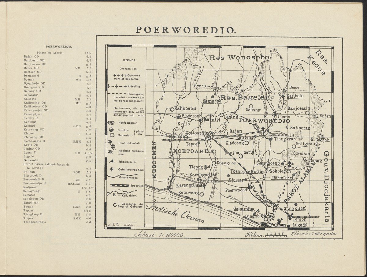
This black-and-white map shows the Purworejo subdistrict (old spelling ‘Poerworedjo’), an area located in Central Java, Indonesia, about 60 kilometers from Yogyakarta and 40 kilometers from Borobudur, the world's largest Buddhist temple. Despite the fact that this map has been published in the Atlas of the missions of the Reformed churches in the Netherlands, this map shows, besides the location of ‘institutionalized churches’, the coexistence of missionary work and the colonial project.
In this map, initially elements that clarify the administrative division of the colonial area stand out, such as governments or department boundaries, district and sub-district places, but also roads and railways or facilities such as schools and medical emergency services. Therefore, at first sight this map rather seems to represent the geographical division and the (colonial) territorial (re)structuring that has been applied to the landscape.
Due to the long history of Dutch influence in the colonial Dutch East Indies, Protestantism had also penetrated the area for some time and had been partly institutionalized. This map attests to the presence of missionaries in that underlined place names indicate where missionary work is performed, although it does not seem important which specific mission societies are serving locally. Nor does the map directly show the full impact of the presence of missionary work in the area. If we take a closer look at the map, it appears that wherever there are schools, missionary activity also takes place. The geographical distribution of missionary work appears to be more coastal oriented rather than inland, and more along roads and rivers than in remote places; thus, focusing on the places that have been made more accessible by the colonial infrastructure. At the bottom right of the map is a statement that each box on the map is ‘1 hour away’, important to know for any itinerant missionary who wants to consult the map.
The map appeared in the Atlas of the missions of the Reformed churches in the Netherlands, published in 1932, which contains ten maps. The maps had previously appeared in Het Zendingsblad van de Gereformeerde Kerken in 1931 and 1932 and were later collected in this atlas. The publication was cheap, in black-and-white, to keep costs down. The objective is stated in the preface: ‘However, this atlas can certainly be useful to promote the knowledge of the mission of the Reformed Churches and thereby serve the mission’. The maps are accompanied by a lot of factual organizational and financial information. They were drawn by Lambertus Gerhardus Goris (1859-1945) and the atlas was published by W. Breukelaar, both ministers in the Reformed Church.


