Maps with a message: missionary cartography ca. 1850-1950

Missionary maps have great exhortative power. At a single glance, they do not just offer an attractive image or geographical information: they are a call to arms, appealing to the observer to support the propagation of the gospel. This makes missionary cartography a fascinating topic: maps contain a message. Old missionary maps carry with them the heavy load of the history of mission, the mixed heritage of imperialism, suppression and racism as well as education, development and medical care. Therefore, their historical significance is not limited to the expansion of Christianity, but also connects to the development of global relations and imperialism more general. The maps in this exhibition are a lens on Western attitudes with regard to the non-Western world.
The digital exhibition of missionary cartography is thematically arranged and has the following sections respectively:
World maps
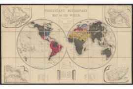 'The Protestant missionary map of the world', 1846 A cartographic showpiece!
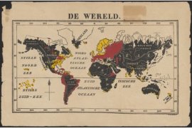 'De wereld', by T.M. Looman, 1850 The spread of protestantism
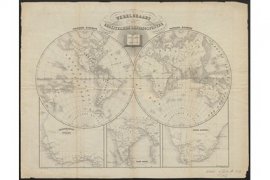 'Wereldkaart der christelijke zendingsposten', 1851 The global ambition of the missionary movement!
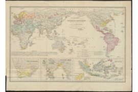 'Godsdienst en Zendingskaart voor de nieuwe tijd', 1854 One of the earliest Dutch missionary world maps!
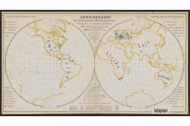 'Zendingkaart der Evangelische Broedergemeente', ca. 1868 With a subdivision into Christian and pagan areas
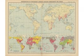 ‘Distribution of protestant mission stations [...]’ and ‘World – languages of commerce, means of traffic &c.’. In: 'World Missionary Atlas', 1925 The history of colonial expansion and exploitation in a nutshell


Colonial maps
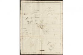 'Chart of part of the Feejee islands [...]', 1799 Commissioned by one of the first missionary organizations
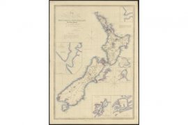 'Chart of New Zealand from original surveys', 1851 Partly based on geographical information from the Church Missionary Society
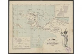 'Kaart der Nederl. bezittingen op het eiland Nieuw-Guinea ten dienste der Utrechtsche Zending', 1863 A map with an exotic touch
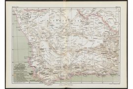 'Das Capland [...]'. In: 'Allgemeiner Missions-Atlas', 1867 When geography and mission go hand in hand
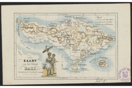 'Kaart van het eiland Bali ten dienste der Utrechtsche Zending', ca. 1875 Difficult conversions on a Hindu island
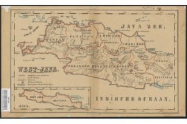 West-Java, [1881] Controversial missions!
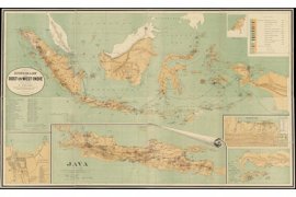 'Zendingskaart van Oost- en West-Indië', 1891 One of the most beautiful Dutch missionary maps!
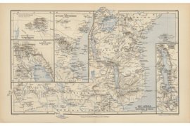 'Ost-Afrika mit Anschluss des Südlichen Central-Afrika'. In: 'Neuer Missions-Atlas', 1896 Interweaving imperialism and mission
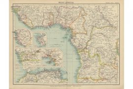 ‘West Africa’. In: 'Statistical atlas of Christian missions', 1910 With the locations of the Protestant mission posts
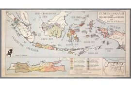 'Zendingskaart van Nederlands Oost-Indie en Suriname', 1930 A popular missionary map
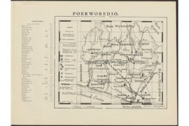 ‘Poerworedjo’, in: 'Atlas van de zendingsterreinen [...]', 1932 Published by preachers of the Protestant church
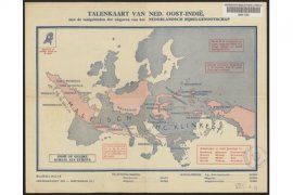 'Talenkaart van Ned. Oost-Indië, met de taalgebieden der uitgaven van het Nederlandsch Bijbelgenootschap', 1936 A mission area in perspective
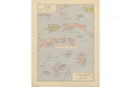 'Molukken [...]', in: 'Atlas van de terreinen der Protestantsche zending', 1937 With the regions of the Moluccan church
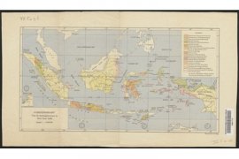 'Overzichtskaart van de zendingsterreinen in Ned. Oost-Indië', 1939 Mission regions instead of mission posts
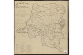 'Congo belge : carte des missions protestantes', 1946 With the locations of over 40 mission organizations
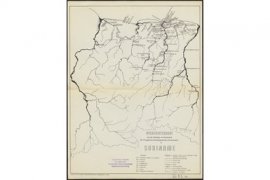 'Overzichtskaart van het Zendings- en Kerkewerk der Evangelische Broedergemeente (Hernhutters) in Suriname', 1960 Dutch missionaries in Surinam


Exploration maps
- 'Chart of part of the Feejee islands [...]', 1799 Commissioned by one of the first missionary organizations
- 'Chart of New Zealand from original surveys', 1851 Partly based on geographical information from the Church Missionary Society
Atlas maps
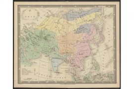 ‘Asia’ and ‘North America’ in 'An atlas [...] designed to show the stations of the protestant missionaries', 1839 A socio-political division of the world in colors
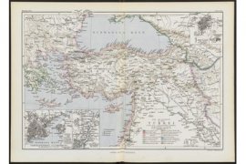 'Die Missionen in die Türkei'. In: 'Allgemeiner Missions-Atlas', 1867 Professional missionary cartography!
- 'Das Capland [...]'. In: 'Allgemeiner Missions-Atlas', 1867 When geography and mission go hand in hand
- 'Ost-Afrika mit Anschluss des Südlichen Central-Afrika'. In: 'Neuer Missions-Atlas', 1896 Interweaving imperialism and mission
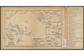 ‘Australien und die inseln im Stillen Ocean’, 1905 The spread of Christianity as a success story
- ‘West Africa’. In: 'Statistical atlas of Christian missions', 1910 With the locations of the Protestant mission posts
- ‘Distribution of protestant mission stations [...]’ and ‘World – languages of commerce, means of traffic &c.’. In: 'World Missionary Atlas', 1925 The history of colonial expansion and exploitation in a nutshell
- ‘Poerworedjo’, in: 'Atlas van de zendingsterreinen [...]', 1932 Published by the preachers of the Protestant church
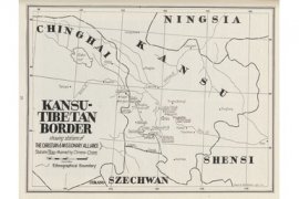 ‘Kansu-Tibetan Border, showing stations of the Christian and Missionary Alliance’. In: 'Missionary Atlas' 1936 From an atlas of the American missionary movement CAMA
- 'Molukken [...]', in: 'Atlas van de terreinen der Protestantsche zending', 1937 With the regions of the Moluccan church
- 'Overzichtskaart van de zendingsterreinen in Ned. Oost-Indië', 1939 Mission regions instead of mission stations
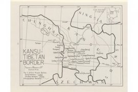 ‘Kansu-Tibetan border’. In: 'Missionary Atlas', 1950 The American mission movement in China


Educational maps
- 'De wereld', by T.M. Looman, 1850 The spread of Protestantism
- 'Zendingskaart van Oost- en West-Indië', 1891 One of the most beautiful Dutch mission maps!
- 'Zendingskaart van Nederlands Oost-Indie en Suriname', 1930 A popular mission map
Thematic maps
- ‘Distribution of protestant mission stations [...]’ and ‘World – languages of commerce, means of traffic &c.’. In: 'World Missionary Atlas', 1925 The history of colonial expansion and exploitation in a nutshell
- 'Talenkaart van Ned. Oost-Indië, met de taalgebieden der uitgaven van het Nederlandsch Bijbelgenootschap', 1936 A mission area in perspective