
Thematic maps
within the digital exhibition 'Maps with a message: missionary cartography ca. 1850-1950'
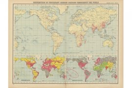 ‘Distribution of protestant mission stations [...]’ and ‘World – languages of commerce, means of traffic &c.’. In: 'World Missionary Atlas', 1925 The history of colonial expansion and exploitation in a nutshell
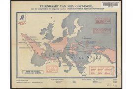 'Talenkaart van Ned. Oost-Indië, met de taalgebieden der uitgaven van het Nederlandsch Bijbelgenootschap', 1936 A mission area in perspective

