
Hydrology, water resources and global change
Water is the lifeblood of the earth. Its presence is a necessity for life, it shapes our landscapes through rivers, glaciers and lakes, transports sediments and nutrients from the mountains to the sea and its presence in the atmosphere makes earth a habitable planet where temperatures are neither too hot nor too cold. Hydrology studies the water cycle and its importance in system earth.
At Utrecht University we study hydrological processes from the scale of the smallest catchment, to continental and even global scale. We try to discover how climate change, land use change and economic and population growth affect water availability, water quality and water demand. We attempt to assess the likelihood of current and future floods, droughts and water scarcity, with the emphasis on the effects on humans and the environment.

To this end we combine fieldwork, remotely sensed data with high performance computing and numerical modelling techniques. We are not only interested in the assessment of detrimental change, but also in analyzing possible solutions. Thus, our research output not only provides new scientific insights, but also contributes to the IPCC reports, policy reports by UNESCO, UNCCD and World Bank, web resources of WRI (Aqueduct Water Risk Atlas and Aqueduct Global Flood Analyzer) and supports National Water and Environmental organizations (Rijkswaterstaat, PBL).
Hydrologic research at UU has several focus areas: global modelling of hydrology and water resources under global change, where we have developed the next generation global hydrology and water resources model; modelling and forecasting of hydrologic extremes, where we try to understand changes in occurrence of floods and droughts in order to better predict these events; mountain hydrology, which focusses on research on glacio-hydrological processes and change in high mountains, mostly in the Himalayas; and, together with the research institute Deltares, the modelling of fresh-salt water distributions in delta areas.
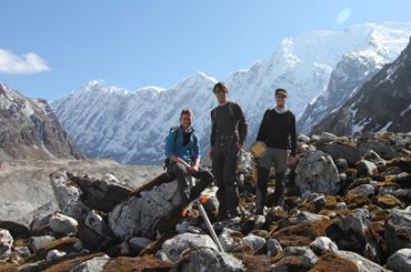
Mountain hydrology
Mountains play a pivotal role for societies worldwide. The mountain hydrology group at Utrecht University provides cutting-edge science.
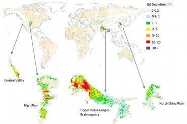
Global groundwater depletion
Population growth, economic development and urbanisation has resulted in many of the aquifers around the world are being depleted.