Reading the rocks to find ancient water on Mars
Extra-terrestrial equivalent of the River Rhine
It was already known that there must have been water on Mars, but now the first evidence of rivers in long-term action preserved in exposed cliff-faces has been found. “Rivers that continuously shifted their gullies, creating sandbanks, similar to the Rhine or the rivers that you can find in Northern Italy.” Using high-resolution orbital imagery of the Martian surface, an international team of scientists discovered the stratigraphic product of multiple extensive fluvial-channel belts in an exposed vertical section at Izola Mensa in the northwestern rim of the Hellas Basin. The study recently appeared in the prestigious journal Nature Communications.
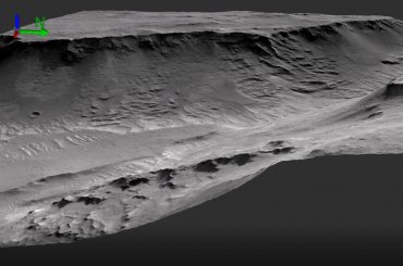
A 200 meter high rocky cliff (twice the height of the White Cliffs of Dover) tells a tale of an ancient watery landscape. These are sedimentary rocks, 3.7 billion years old, and were formed by rivers that were likely active for over 100,000 years of Martian history. In the last decades, thanks to an armada of orbiters, rovers and landers, scientists have already uncovered a great deal about Mars’ ancient past. In particular, researchers have uncovered substantial evidence that the planet's surface was once traversed by significant volumes of flowing water. Now Dr Francesco Salese and Dr William McMahon along with an international team composed by scientists from Italy, UK, France and The Netherlands examined high resolution (25cm/pixel) satellite data of the Hellas (Izola mensa) region to study the characteristics of the newly discovered sedimentary rocks. Their study adds a new piece to this extraterrestrial jigsaw puzzle, providing novel insight into just how much water occupied these ancient landscapes.
Several meters deep
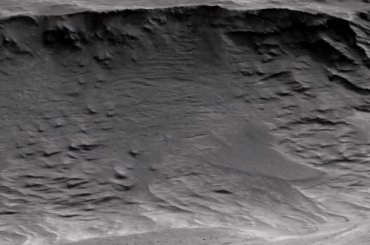
Says Francesco Salese - a geologist at Utrecht University (The Netherlands) and senior scientist at the International Research School of Planetary Sciences (Italy) - “OK, it is not like reading a newspaper, but the extremely high resolution imagery allowed us to ‘read’ the rocks as if you are standing very close to the cliff. Unfortunately we don’t have the ability to climb, to look at the finer-scale details, but the striking similarities to sedimentary rocks on Earth leaves very little to the imagination.” The packages of oblique layers attest to ancient rivers with channel depths several meters deep. The researchers made 3D animations of the investigated area; a bird's-eye view and a detailed picture. Click on the images below to watch the animations.

3D animation: bird's eye view
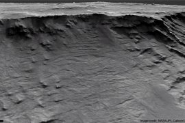
This rock face is made up of scours, seen here as shallow U-forms between the parallel rock layers.

3D animation: detail
The cliff faces in this image preserve ancient channel-forms, archived evidence of active rivers on the Martian surface over 3.7 billion years ago.
Large lake
Located in the Martian southern hemisphere, the Hellas impact crater has been of interest to planetary scientists for years. It's one of the largest impact craters in the Solar System, with an altitude difference from crater rim to floor of over 9,000 m. Landforms preserved on the surface provide evidence of a network of ancient rivers, deltas and outflow channels, with mineral evidence suggesting the region once hosted an incredibly large lake.
Ancient rock record
William McMahon – a geologist at Utrecht University - says that: "Here on Earth, the stratigraphy (i.e. the order and position of sedimentary layers) of sedimentary rocks has been used by geologists for generations to place constraints on what conditions were like on our planet millions or even billions of years ago. Now we have the technology to extend this methodology to another terrestrial planet, Mars, which hosts an ancient sedimentary rock record which extends even further back in time than our own.”
Lucky
The time recorded in the 200-m-thick succession represents only a fraction of the total time fluvial deposition was ongoing in this region. The majority of strata and time will have either been lost to erosion, or preserved in outcrops as of yet undiscovered, or currently buried and not amenable to study and it can’t be assumed that the modern surface represents the ancient surface at all. Nor is it known how far these original rivers traversed. For all of this, Salese, McMahon and their colleagues were able to identify stacking patterns in the fluvial deposits, noting changes in sedimentation styles and suggested mechanisms for their creation. The researchers were lucky: the rock face was just slanting enough and the satellite was able to photograph it from exactly the right point.
Sustained river deposition
The evidence points at prolonged water discharges that are most consistent with a precipitation-driven hydrological cycle. This conclusion aligns with previous arguments for the prolonged presence of water on the Martian surface. “The study demonstrates sustained river deposition on Mars 3.7 billion years ago. Such perennially flowing rivers would require an environment capable of maintaining large volumes of water for extensive time-periods, and almost certainly necessitated a precipitation-driven hydrological cycle. More in line with slower climatic change, and less in line with catastrophic hydrologic events. This kind of evidence, of a long-lived watery landscape, is crucial in our search for ancient life on the planet,” concludes Salese. “For the first time, orbital data has allowed us to examine, through detailed high-resolution architectural analysis, a large (1500 m by 200 m) outcrop, and draw reliable paleoenvironmental interpretations based on sedimentary-stratigraphic evidence.”
Publication
Francesco Salese, William J. McMahon, Matthew R. Balme, Veronique Ansan, Joel M. Davis & Maarten G. Kleinhans, ‘Sustained fluvial deposition recorded in Mars’ Noachian stratigraphic record', Nature Communications 11, 2067 (2020), https://doi.org/10.1038/s41467-020-15622-0


