
New evidence for mysterious cartographic tradition
Oldest nautical chart of Africa wasn’t made by the Portuguese
Serious doubt has arisen regarding the common belief that the oldest existing maps of the continent of Africa were made by Portuguese explorers in the 15th century. Research at Utrecht University has shown that their knowledge and techniques were insufficient to the task. But who did make the maps is still a mystery - one that has stumped the researcher in earlier work.

Explorers
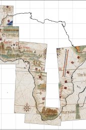
Let us go back to the fifteenth century; the beginnings of the Age of Discovery. Portuguese explorers braved the seas around the African continent and accurately charted their course using the navigation techniques available at the time. When they returned home, cartographers used their measurements to produce the Cantino Planisphere: the oldest map of the world with a realistic depiction of the continent of Africa.
Irreconcilable
Historians generally believe that this is how the Cantino Planisphere came about, but research by Roel Nicolai indicates that this explanation is extremely unlikely to be correct. Using mathematical analysis, he has shown that the shape of Africa depicted on the historical worldmap is inconsistent with the principles of Portuguese navigation and cartography. Their methods should have produced predictable distortions that are absent on the map.
Mosaic
Instead, his research indicates that the Cantino Planisphere is most likely a compilation of regional maps or charts that the Portuguese combined into a mosaic image. The individual maps all share the same map projection, which indicates that the cartographers took the spherical form of the earth into consideration in a correct manner, which itself is also irreconcilable with the Portuguese approach. Although they realised that the earth was round, they did not take that into account in their navigation and cartography.
Lost tradition
Who did produce these accurate regional maps, however, remains a mystery that recalls Nicolai’s PhD research in 2014. At the time, the researcher indicated that nautical charts of the Mediterranean and Black Sea have a different origin than had previously been assumed. As his dissertation explained, the medieval cartographers could not have made those maps due to a lack of knowledge and suitable methods, so they must have originated in a tradition that has since been lost to history.
Who did create the charts is an intriguing question, and it would be wonderful if a multi-disciplinary team of researchers would take up the task
Avoiding speculation
Nicolai is neither willing nor able to speculate on the culture to which the mysterious cartographic tradition belongs. “In this study, I tested the hypothesis that the Portuguese surveyed and charted Africa. That resulted in a refutation of this hypothesis”, according to the researcher. “But that does not answer the question of who did create them. That is of course an intriguing question, and it would be wonderful if a multi-disciplinary team of researchers would take up the task.”
Publication
The Mapping of Africa on the Nautical Charts of the Age of Discovery
Terra Incognita, 20 November 2021. DOI: 10.1080/00822884.2021.1995829
Roel Nicolai*
*Affiliated with Utrecht University.